 |
| Driving through Nevada |
 |
| In California, near the Park |
In the daylight it looks stark and unforgiving. Aileen wondered why anyone would live in such a place and, guess what, not many seemed to live along the route we took (Route 6 west). Occasionally we would see an isolated farm or a government testing range (I don’t even want to know what happens in these) but that’s it.
We did see a gentleman sitting at a rest stop (use the term
very loosely) with no car anywhere in site.
The nearest town or even cross road was maybe 50 miles away. We travelled past him doing 80 mph so no, we
did not stop.
The landscape stayed the same almost all the way to Yosemite
– a mix of soft browns and red tones across both the flat areas and through the
numerous small mountain ranges. It is
amazing how much land is dedicated as National Forest out this way. The forests extend for hundreds of miles and
then just change names to another national forest. The east does not have anywhere close to this
much “public” land.
We continued through Nevada and as we approached Yosemite
the landscape changed significantly. The
closer we got the more mountainous it became.
The last 50 miles before the park are as winding as within the park –
that was another theme that became evident within and around Yosemite – the roads
are so curvy that your average speed might be 25 to 30 mph so it takes awhile
to get anywhere.
 |
| Just outside Tioga Pass entrance |
Anyway, the last stretch before the park was mountainous and
the type of mountains even changed. They
became harder and more granite-like. Through
Nevada the hills all seemed to be weathering away in front of us where as near
Yosemite they took on a stronger form, a more commanding form.
 |
| Just outside Tioga Pass entrance |
 |
| Tioga Pass |
 |
| Tenaya Lake near Tioga Pass |
 |
| Tenaya Lake |
We then stopped at Olmstead Point which was named after the famous landscape architect. Seems Olmstead was instrumental in developing best practices for the sequoias in the park and park maintenance in general. This lookout offered our first view of half-dome, a granite dome with one sheer face. From this spot we could also see Cloud’s Rest. We sat on rocks which felt like a natural amphitheater with the show being half-dome and the valley. A very beautiful and peaceful spot. We sat there for almost an hour and soaked it all in. One of the best views / vantage points so far.

We left Olmstead Point and travelled to Yosemite Valley. This is a change in elevation from say 9,000 to 4,000 so the ride was winding and on a constant downgrade. Even got to go through a few tunnels as we got close to the valley floor.
 |
| Half-Dome from Olmstead Point |
 |
| Still at Olmstead Point |
 |
| Aileen being funny |
 |
| Olmstead Point |

 |
| Valley en route from Tioga to Yosemite Valley |
We left Olmstead Point and travelled to Yosemite Valley. This is a change in elevation from say 9,000 to 4,000 so the ride was winding and on a constant downgrade. Even got to go through a few tunnels as we got close to the valley floor.
Yosemite Valley is the focal point of this park and that means
people. We got to the valley area around
6:30 so it was not too bad. There is a main
road the loops around within the valley which offers great views of the
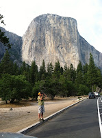
adjacent peaks including the famous El Capitan.
There are also numerous waterfalls off these peaks.
 |
| El Capitan |

We left the valley and headed south to Oakhurst, a small town outside the park where our hotel was located. It took 90 minutes to go from the valley to our hotel and Aileen was spent by the time we got to the hotel – more of those winding and narrow roads. We talked about the roads quite a bit and agreed it was easier to be the driver instead of passenger because as passenger you weren’t in control and you had a view of the roadside which often times dropped out of sight. We joked that Colleen would never make it on these roads.
 |
| El Capitan |
 |
| El Cap again |
We left the valley and headed south to Oakhurst, a small town outside the park where our hotel was located. It took 90 minutes to go from the valley to our hotel and Aileen was spent by the time we got to the hotel – more of those winding and narrow roads. We talked about the roads quite a bit and agreed it was easier to be the driver instead of passenger because as passenger you weren’t in control and you had a view of the roadside which often times dropped out of sight. We joked that Colleen would never make it on these roads.


Another great post. The photos are blowing me away, I want to be there so bad! What a fun adventure! Love you guys. matt
ReplyDeleteThanks Matt.
ReplyDeleteThis particular part of the trip looks amazing. Matt really wants to go to Yosemite. We will have to get there maybe next year before he goes to college. You can give us hints on how to best handle this! I love the shots of Olmstead Point. You did the right thing soaking that view up. You both look content, happy and at peace in the photos. This trip is really special and thanks for sharing it with all of us here in the "blog" spot!
ReplyDeleteWe loved it and would definitely recommend you guys see it.
ReplyDelete